The University of Salford’s THINKlab has developed a new digital drone visualisation platform which has the potential for changing the way users are able to respond to disasters more effectively and for supporting post disaster reconstruction efforts.
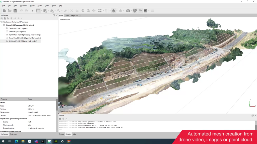
The innovative platform will mean that stakeholders are able to interpret data more quickly to establish an accurate situational awareness on the ground and make better informed decisions during disaster situations. This environment will allow emergency operation centres to receive live videos from drones and construct a 3D representation of the disaster areas to understand the scale of the impact of a disaster on communities and the physical infrastructure.

By linking this drone environment with a rich city information model, provided by the MOBILISE 3.0 digital disaster management platform, decision-makers can extract further information about the built environment, infrastructures and communities to establish a more holistic and detailed view of the situation and ultimately, to save lives.
Designed and programmed by the THINKlab team, the drone simulation programme works by using the Unity gaming engine which is a market-leading platform for creating interactive real-time 3D content. It has been designed to be used on a laptop or a tablet as well as on large touch screen devices which are used by many disaster management centres.
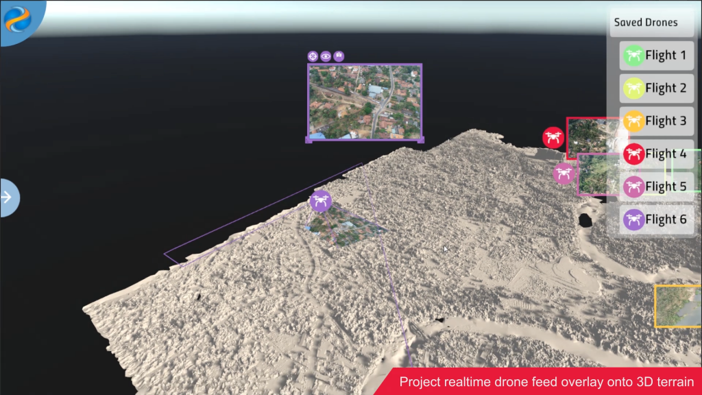
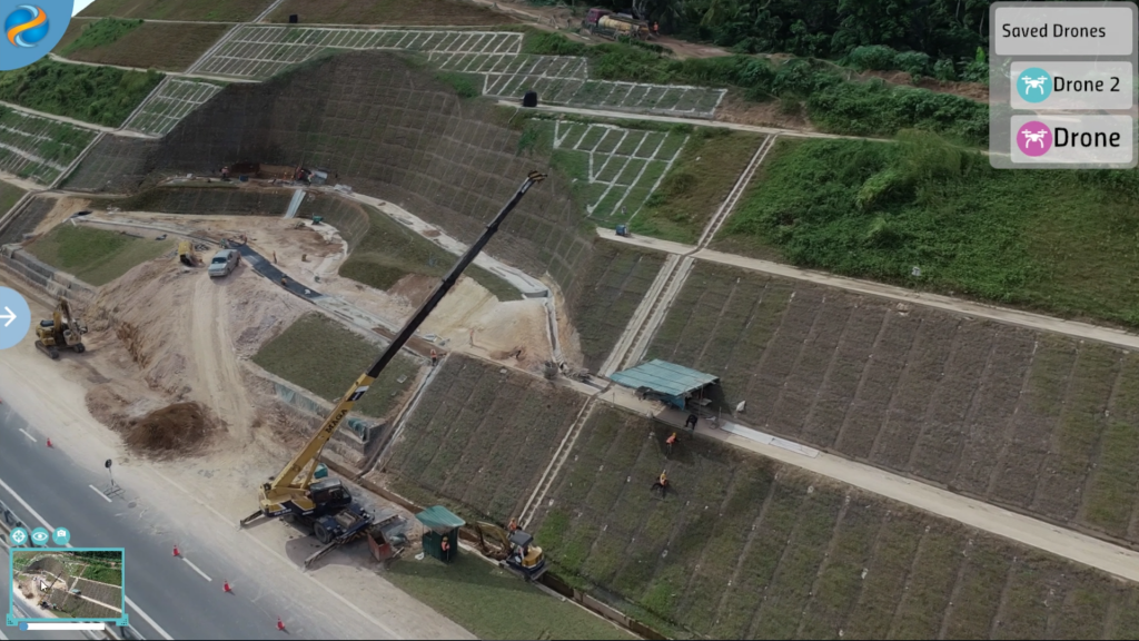
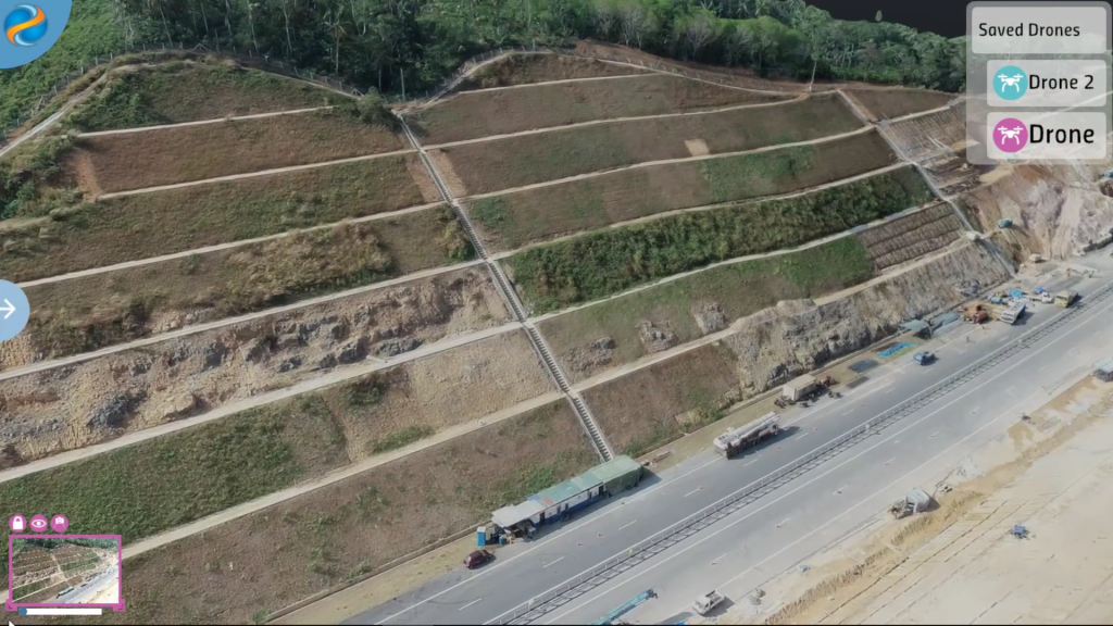
Users can overlay data from the MOBILISE 3.0 platform onto the terrain produced using the drone data and can click on specific buildings and landmarks to more information about the impacted infrastructure. The platform has the ability to display and manage multiple drone flights by using live or pre-captured data so users can follow individual flight paths whereby they can zoom in to see the drone’s camera view, or can project what the drone is currently seeing onto a 3D terrain. Users can overlay what the drone sees (after a landslide or a flood for example) and compare it with terrain information which has previously been captured and processed in order to then view the impact of that landslide or flood on the terrain.

Developed as part of the MOBILISE project and funded by Global Challenges Research Funds (GCRF) and The Engineering and Physical Sciences Research Council (EPSRC), MOBILISE 3.0 gathers information and data from sensors, satellites, city information models and communities to present an innovative 3D collaborative environment for agencies to work together to prepare and respond to disasters. The platform provides stakeholders with a deeper understanding of vulnerability and allows them to explore ‘what-if’ scenarios which then help disaster management agencies to agree on appropriate disaster mitigation measures which will improve and build resilience in disaster-prone areas. It is currently being used by disaster management centres in Sri Lanka, Malaysia and Pakistan to support their disaster management activities.
The drone data visualisation environment also supports agencies in their post-disaster reconstruction activities. In this regard, the MOBILISE project team has been working with Sri Lanka’s National Building Research Organisation (NBRO) to support their rapid landslide disaster investigations and reconstruction activities to build back better. The drone visualisation environment can be used by NBRO’s officers to capture drone images after a landslide incident and conduct more specific analysis such as future risk within the site, impact analysis, land use analysis, cost estimations and soil volume calculations, using a 3D environment of the affected landslide area. The studies that can be conducted using the drone visualisation are landslide mitigation activities and the development of resettlement programmes and community-based disaster risk reduction strategies.
The NBRO has taken a further step to additionally develop their technology by recently procuring several multi-spectrum images’ capturing drones, thermal sensor-mounted drones and RTK drones. Their partnership with the THINKlab and other highly technologically led partners will mean that they are able to support more communities and strengthen their disaster risk reduction strategies, resettlement action monitoring and landslide mitigation site monitoring.

The digital drone visualisation platform can also be used for other applications such as urban planning and construction site monitoring. By using the drone visualisation platform integrated with the city information model provided through the MOBILISE 3.0 platform, planners can create up-to-date city models in a short period of time to support urban simulation and stakeholder engagement.
Mike Polshaw (VR Software Engineer) who has worked on the programme with Adam Sinclair (VR Content Creator) said: “The MOBILISE Drone Visualisation application allows any user to easily and intuitively view 3D data captured by drones alongside other city-data. Due to its ease of use, informed decisions can be made about planning, rebuilding and response issues in a much shorter timeframe than other analysis methods would allow. The application is built on proven industry standards and integrates with the capability of the MOBILISE platform so non-experts can immediately make sense of, and utilise, the available data.”
Adam Sinclair (VR Content Creator): We have developed a streamlined user interface to communicate complex data in a simple format, creating the ability to process potentially lifesaving information rapidly and effectively. We’ve worked from the ground up with our stakeholders and taken their feedback to create a range of unique and bespoke tools which are specific to their needs.”
Professor Terrence Fernando, Director of THINKlab said: “We are very excited by the opportunities presented by the drone data visualisation environment. It now allows organisations to capture urban spaces in a very short period at low cost, and to simulate “what-if” scenarios to design and build resilient environments for citizens as well as responding to disasters efficiently. We are currently trialling this environment in Sri Lanka for reconstruction projects after landslides and hope to try it out in other contexts and countries.”

Notes:
Funded by the Global Challenges Research Fund (GCRF) and The Engineering and Physical Sciences Research Council (EPSRC), the MOBILISE project focuses on LMIC communities in Sri Lanka, Malaysia and Pakistan who are regularly affected by natural disasters such as flooding, landslides and earthquakes.
The MOBILISE platform is targeted at helping various governments to implement the Sendai Framework Priority 1: ‘Understanding Risks’ and Priority 2: ‘Risk Governance,’ as established by the United Nations.
The MOBILISE project team collaborate with international partners and organisations working across government, disaster management, computer science, education and science in Sri Lanka, Malaysia and Pakistan
Led by the THINKlab Director, Prof Terrence Fernando, the project is developing a digital infrastructure which offers intelligence to multiple stakeholders who can work together to help reduce the impact of natural disasters on their local communities. Set up in May 2017, the project will run until2021. Utilise this link for more information about the MOBILISE project.